Bismillah ir-Rahman ir-Rahim
This was my last hiking trip in Australia before flying back home. The name
of the mountain does intrigue me a lot. Remarkable its name, why does it so?
Well, from 50km away we can see an outline of a massive mount over vast surrounding
plain. Remarkable, one will say.
It was a 290km journey from Adelaide that took about 3.5 hour drive. The main trail up to Mount Remarkable summit is in Melrose. But, we camp overnight in Mambray Creek campsite, another 20km from Melrose. Mambray Creek campsite is one of the best outback campsite in Australia complete with toilets and bathrooms. At night we slept under the bright starlight and in the morning we woke up through the sound of birds whistling. Lovely.
Mount Remarkable National Park is located about 230km from the city of Adelaide. It consists of the Alligator Gorge, Mambray Creek and of course, the Mount Remarkable itself. This trip happened a week after we went to Wilpena, so once again we went through the same route, but instead of going straight to Quorn we diverted to Melrose. There are entrance fee to the National Park. We paid $24, inclusive of entrance for a car and one night camp, kindly note that we are students so we paid concession price.
 |
| I like the "kesempoian" of this signage. And the yellow bike too...classic! |
 |
| The Mount Remarkable from afar. |
 |
| Part of the Mount Remarkable National Park, heading to Mambray Creek through the Horrock's Pass. |
 |
| Us! |
 |
| Driving through Horrock's Pass |
Alligator Gorge is one spectacular gorge that was believed to be an ancient dry river bed. The river cut through ancient quartzite rocks of Alligator Creek. As it was going to be dark soon, we took the shortest walk through the gorge. It was a 90 minutes walk of 2km loop trail. Alligator Gorge located about 14km from the town of Wilmington and can easily be accessed by car. The trail starts from the car park area and there is a staircase leading down to the gorge floor.
 |
| Lunch di car park, lapo gile.... |
 |
| ...heading back to the campsite, sunset! |
 |
| Ready for dinner |
 |
| Tom yum nyum...nyum.... |
 |
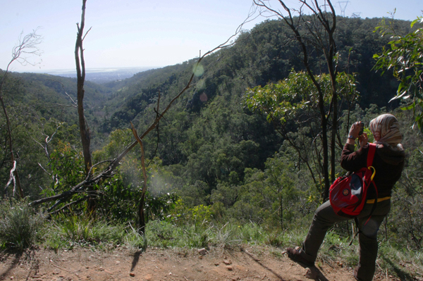
| Great view of the Spencer Gulf |
 |
| Spencer Gulf from satellite view |
|
The next morning, well not quite morning, after late breakfast, we started our journey back to Melrose for the summit hike of Mount Remarkable. We stop by at an old coffee shop which was used to be a blacksmith's workshop; and which was built in 1865. The owner of the coffee shop conserved most of the outlook and inlook of the blacksmith's workshop. You can find the tools and machinery around the shop.
 |
| K.g posing style bini blacksmith |
 |
| Inah concentrate baca article pasal Mount Remarkable |
 |
| Coffee Shop entrance |
 |
| The coffee shop |
 |
| Hot choc during hot summer day....tak masuk, tak masuk... |
And, here we go....the summit hike of Mount Remarkable.
Mount Remarkable stands at 955m high in the Southern Flinders Ranges, South Australia. It is being considered as the boundary between the arid north and wetter south of the range containing flora and fauna of both regions. The summit hike trail is part of the famous Heysen Trail and offers impressive view of the Willochra Plain and Spencer Gulf. The hike listed as moderate with some moderate inclines and loose, uneven surface. Estimated time is 5 hours with 12.2km return.
 |
| Us before the hike. Masa ni cukup lah panas, sunburn x hengat.... |
 |
| This is actually the tricky part, memang kalau silap langkah terjunam ke bawah... |
 |
| Willochra Plain |
 |
| If you look closely, there is a plane wreck down the slope. It was believed to be a light aircraft that crashed in 1970s. |
 |
| Ini agak scary, adalah dalam 600mm wide, trail itu. |
 |
| And, it ends here. |
 |
| Agak mengecewakan sebab ingatkan akan nampak view yang marvelous kat atas ni, rupanye view adalah sepanjang perjalanan, not bad,...not bad. |
Well, before we went for the trip i did some research on Mount Remarkable. I really thought that up on the summit, we will get the best view of the plain and Spencer Gulf. But, the view was actually during our hike through the trail. Mount Remarkable is rather bit different from any other mountain trail, because I wonder why the trail was prepared to be around the slopes rather than cutting through the slopes resulting a long stretch of walking trail. The act of preserving i guess. Anyhow, it was a remarkable trip. I really enjoyed the hike and the views along the way.